Geotagging is the process of determining or estimating the geographic position of an address (for example – “309 George Street, Sydney, NSW”), it allows CLCs to report on clients and services distributed across various regions.
The purpose of geotagging is to record where each client was served from, and the logic of geotagging, put simply, is that the client address entered before the creation of a service will be tagged onto this service. This in turn means that an address modified after the creation of a service will not be tagged to the associated service.
We recommend gathering full address during early intake stage so that you have everything ready for geotagging before creating a service.
The geocoding data is based on widely used geographical standards from sources such as the Australian Bureau of Statistics, State Territory and Federal Electoral Offices, and Australia Post. Common administrative boundaries include:
Local Government Area (LGA)
Minimum criteria of data input for successful geotagging: Street Name + Street Type + Postcode
A Non-ABS Structure of the Australian Statistical Geography Standard (ASGS). LGAs are defined by the Departments of Local Government, or their equivalent in each state or territory, excepting the Australian Capital Territory. The ABS approximates the officially defined boundaries with aggregations of Mesh Blocks.
Statistical Areas Level 1 (SA1)
Minimum criteria of data input for successful geotagging: Street Name + Street Type + Postcode
Designed to maximise the spatial detail available for Census data. Most SA1s have a population of between 200 to 800 persons with an average population of approximately 400 persons. SA1s aim to separate out areas with different geographic characteristics within Suburb and Locality boundaries. In rural areas they often combine related Locality boundaries. SA1s are aggregations of Mesh Blocks.
Statistical Areas Level 2 (SA2)
Minimum criteria of data input for successful geotagging: Postcode
Designed to reflect functional areas that represent a community that interacts together socially and economically. SA2s generally have a population range of 3,000 to 25,000 persons and have an average population of about 10,000 persons. SA2s are aggregations of whole SA1s.
Statistical Areas Level 3 (SA3)
Designed for the output of regional data. SA3s create a standard framework for the analysis of ABS data at the regional level through clustering groups of SA2s that have similar regional characteristics, administrative boundaries or labour markets. SA3s generally have populations between 30,000 and 130,000 persons and they are aggregation of whole SA2s.
There are other administrative boundary options available in CLASS, please refer to Administrative Boundaries defined – CLASS Documentation
Selecting a different administrative boundary might affect the number of clients/services you will get from your report, it is useful to be aware that the same area name may exists in multiple administrative boundaries, but it does not mean they also share the same geographic boundary.
For example, The SA3 Yarra Ranges is separate to the LGA of Yarra Ranges and they both have different geographic boundaries, some of which overlap, and some do not. If you want the number of clients in the Yarra Ranges LGA, then SA3 will not be an accurate indicator.
| Source ABS Maps | |
|---|---|
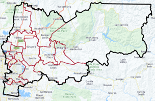 |  |
As you can see from the map, the LGA map includes more areas than the SA3 map. So, in theory you would expect your LGA count to be roughly double the SA3 count.
Troubleshoot these counts by reviewing the address validation matrix – CLASS address Validation Matrix
In summary, lower quality address data (i.e., no street details) is more likely to get you a correct match for SA2 (and by logic an SA3) instead of an LGA. Every service that does not have an SA1 tagged will NOT have an LGA, and services with SA1 tagged may not have an LGA.
The Retag Function in CLASS is designed to fix incorrectly geolocated Services due to inadequate or incorrect primary address information (e.g., Typos, or inadequate knowledge when a service is first entered etc.).
The idea of the Retag function is to first correct the primary address which is attached to the Client Record in the additional details tab. Make sure to test the Address you have entered with the Google Maps button: