Administrative Boundaries defined

Definitions

  • Mesh Blocks are the smallest geographical area defined by the ABS. They are designed as geographic building blocks rather than as areas for the release of statistics themselves. All statistical areas in the Australian Statistical Geography Standard (ASGS), both ABS and Non ABS Structures, are built up from Mesh Blocks. As a result the design of Mesh Blocks takes into account many factors including administrative boundaries such as Cadastre, Suburbs and Localities and LGAs as well as land uses and dwelling distribution. Most Mesh Blocks contain 30 to 60 dwellings although some are specifically designed to have zero. This provides an additional level of confidentiality for data released on the ASGS as the difference in data released on multiple statistical areas is always at least one Mesh Block. Mesh Blocks, like other ABS structures, are stable for 5 years and are updated to reflect changes such as new housing developments every 5 years.Mesh Blocks include a Mesh Block Category that broadly defines primary land uses such as Residential and Commercial. The only statistical data currently available for Mesh Blocks (as of 2017) are total population and dwelling counts from the Census of Population and Housing.
  • Statistical Areas Level 1 (SA1s) are designed to maximise the spatial detail available for Census data. Most SA1s have a population of between 200 to 800 persons with an average population of approximately 400 persons. This is to optimise the balance between spatial detail and the ability to cross classify Census variables without the resulting counts becoming too small for use. SA1s aim to separate out areas with different geographic characteristics within Suburb and Locality boundaries. In rural areas they often combine related Locality boundaries. SA1s are aggregations of Mesh Blocks.
  • Statistical Areas Level 2 (SA2s) are designed to reflect functional areas that represent a community that interacts together socially and economically. They consider Suburb and Locality boundaries to improve the geographic coding of data to these areas and in major urban areas SA2s often reflect one or more related suburbs. The SA2 is the smallest area for the release of many ABS statistics, including the Estimated Resident Population (ERP), Health & Vitals and Building Approvals data. SA2s generally have a population range of 3,000 to 25,000 persons, and have an average population of about 10,000 persons. SA2s are aggregations of whole SA1s.
  • Statistical Areas Level 3 (SA3s) are designed for the output of regional data. SA3s create a standard framework for the analysis of ABS data at the regional level through clustering groups of SA2s that have similar regional characteristics, administrative boundaries or labour markets. SA3s generally have populations between 30,000 and 130,000 persons. They are often the functional areas of regional towns and cities with a population in excess of 20,000, or clusters of related suburbs around urban commercial and transport hubs within the major urban areas. SA3s are aggregations of whole SA2s.
  • Statistical Areas Level 4 (SA4s) are specifically designed for the output of Labour Force Survey data and reflect labour markets within each State and Territory within the population limits imposed by the Labour Force Survey sample. Most SA4s have a population above 100,000 persons to provide sufficient sample size for Labour Force estimates. In regional areas, SA4s tend to have lower populations (100,000 to 300,000). In metropolitan areas, the SA4s tend to have larger populations (300,000 to 500,000). SA4s are aggregations of whole SA3s.
  • State and Territory (S/T) and Australia are spatial units separately representing the geographic extent of Australia, and the States and Territories within Australia. Jervis Bay Territory, the Territories of Christmas Island, Cocos (Keeling) Islands and Norfolk Island are included as one spatial unit at the State and Territory level under the category of Other Territories. Prior to 2016 Norfolk Island was not included in the ASGS. In line with Australian Government announced reforms to the governance of Norfolk Island and its inclusion into the definition of Geographic Australia, the 2016 ASGS has been updated to include the Territory of Norfolk Island.
  • Suburbs Gazetted localities constructed from information in the G-NAF database. It is not the same as ABS State Suburbs
  • Postcodes Are defined from data provides by Australia Post – it is not the Same as ABS Postal Areas.
  • Local Government Area (LGAs) are a Non-ABS Structure of the Australian Statistical Geography Standard (ASGS). Non-ABS Structures are hierarchies of regions that are not defined or maintained by the ABS. LGAs are defined by the Departments of Local Government, or their equivalent in each state or territory, excepting the Australian Capital Territory. The ABS approximates the officially defined boundaries with aggregations of Mesh Blocks.
  • State Electoral Divisions (SED) are an area legally prescribed for the purpose of returning one or more members to the state or territory lower houses of parliament. SEDs are part of the Non-ABS Structures. SEDs are approximated by aggregating the data for Statistical Areas Level 1 (SA1s) that best fit the area.
  • Commonwealth Electoral Divisions (CED) are an ABS approximation of the Australian Electoral Commission (AEC) federal electoral division boundaries. An AEC federal electoral division is an area legally prescribed for the purpose of returning one member to the House of Representatives, Australia’s Federal Lower House of Parliament. Federal electoral divisions are periodically redistributed on a state-by-state basis by the AEC.
  • Remoteness Area (RAs) are an ABS construct that divide Australia and the States and Territories into 5 classes of remoteness on the basis of their relative access to services. RAs are based on the Accessibility and Remoteness Index of Australia (ARIA+), produced by the Hugo Centre for Migration and Population Research at the University of Adelaide. RAs are aggregates of SA1s that are grouped together based on their average ARIA+ score. This Administrative boundary is used to define Priority Clients in CLASS from remote Areas.
  • Indigenous Locations (ILOCs) represent small Aboriginal and Torres Strait Islander communities (urban and rural) with a minimum population of 90 Aboriginal and Torres Strait Islander usual residents. An ILOC is an area designed to allow the release of statistics relating to Aboriginal and Torres Strait Islander people with a high level of spatial accuracy whilst maintaining the confidentiality of individuals. ILOCs are aggregates of one or more SA1s.
  • Indigenous Areas (IARE) are medium sized geographical areas designed to facilitate the release of more detailed statistics for Aboriginal and Torres Strait Islander Peoples. IAREs provide a balance between spatial resolution and population size, which provides the ability to release more detailed socio-economic attribute data than is available on ILOCs. IAREs are aggregates of one or more ILOCs.
  • Indigenous Regions (IREGs)  are large geographical areas loosely based on the former Aboriginal and Torres Strait Islander Commission boundaries. The greater population of IREGs enables greater cross classification of variables when compared with IAREs and ILOCs. IREGs do not cross State or Territory borders and are aggregates of one or more IAREs.
  • More detail on ABS codes can be found here.


What is the Australian Statistical Geography Standard (ASGS)?

The Australian Statistical Geography Standard (ASGS) provides a framework of statistical areas used by the Australian Bureau of Statistics (ABS) and other organisations to enable the publication of statistics that are comparable and spatially integrated. First introduced in 2011, the ASGS replaced the Australian Standard Geographical Classification (ASGC) that had been in use since 1984. The ASGS provides users with an integrated set of standard areas that can be used for analysing, visualising and integrating statistics produced by the ABS and other organisations.

The ASGS is split into two parts, the ABS Structures and the Non ABS Structures.


The ABS Structures
 are areas that the ABS designs specifically for outputting statistics. This means that the statistical areas are designed to meet the requirements of specific statistical collections as well as geographic concepts relevant to those statistics such as remoteness and urban/rural definitions. This helps to ensure the confidentiality, accuracy and relevance of the data. The ABS Structures are stable for five years to enable better comparison of data over time.

They include:

  • SA1
  • SA2
  • SA3
  • SA4
  • Indigenous Locations
  • Indigenous Areas
  • Indigenous Regions
  • Remoteness Areas


The Non ABS Structures
 represent administrative areas for which the ABS is committed to providing a range of statistics. These areas can change regularly as they are not defined by the ABS. As a result the Non ABS Structures are updated annually if significant changes to the areas have occurred. This improves the relevance of ABS data released on these areas. For example, the Local Government Areas (LGAs) are released annually: these represent LGAs that are defined by the State and Territory governments. ABS statistics such as Estimated Resident Population (ERP) are output on these LGA approximations.

Separating the ABS and Non ABS Structures in the ASGS ensures that the ABS can provide statistics on both stable, purpose built statistical areas as well as important administrative areas. This is a key difference to the previous ASGC where all areas were related to LGAs and consequently needed to be updated annually to reflect changes in the LGAs. This key difference is possible because the ASGS uses Mesh Blocks as a common building block for all structures. Mesh Blocks, like other ABS Structures, are stable for 5 years. However, they are small enough that they can accurately approximate the changing administrative areas without changing themselves. Mesh Blocks also provide an additional level of confidentiality for data released on the ASGS, as the difference in data released on multiple statistical areas is always at least one Mesh Block.

They include:

  • Commonwealth Electoral Divisions
  • State Electoral Divisions
  • Local Government Areas


ABS Structures

The ABS Structures are a hierarchy of areas developed for the release of ABS statistical information. Their components are described below.

Diagram 1 depicts the various ABS Structures, their component statistical areas and how they interrelate.

Diagram 1: ASGS ABS Structures

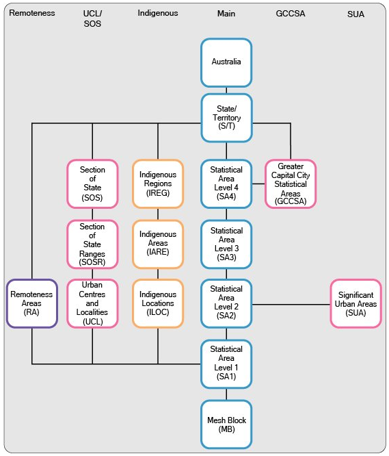
Diagram 2 depicts the various ASGS Non-ABS Structures, their component regions and how they interrelate.

Diagram 2: ASGS Non-ABS Structures

Search